
Category:Cities in the United States
Countries of the Americas: Argentina · The Bahamas · Belize · Bolivia · Brazil · Canada · Chile · Colombia · Costa Rica · Cuba · Dominica · Dominican Republic · Ecuador · El Salvador · Guatemala · Guyana · Haiti · Honduras · Jamaica · Mexico · Nicaragua · Panama · Paraguay · Peru · Saint Vincent and the Grenadines · Suriname · Trinidad and Tobago · United States · Uruguay · Venezuela
Other areas: Cayman Islands · Greenland · Puerto Rico
Other areas: Cayman Islands · Greenland · Puerto Rico
administrative division at the local government level in the United States | |||||
| Upload media | |||||
| Subclass of |
| ||||
|---|---|---|---|---|---|
| Location |
| ||||
| Applies to jurisdiction | |||||
| Different from | |||||
| |||||
Subcategories
This category has the following 27 subcategories, out of 27 total.
!
*
+
A
C
I
M
N
P
Q
S
U
Pages in category "Cities in the United States"
This category contains only the following page.
Media in category "Cities in the United States"
The following 39 files are in this category, out of 39 total.
-
 10 Largest By population 2010.png 1,100 × 700; 106 KB
-
 Abingdon Welcome Sign.jpg 4,727 × 3,660; 3.95 MB
-
 Alabaster Hwy 31.jpg 4,032 × 3,024; 2.1 MB
-
 Brush Factory Lofts, Lower Moyamensing Philadelphia.jpg 3,024 × 4,032; 2.82 MB
-
 Chester, Illinois.jpg 5,852 × 3,905; 4.64 MB
-
 Cities in North America East.png 1,344 × 743; 48 KB
-
 Cities in North America South.png 1,344 × 743; 62 KB
-
 Cities in North America West.png 1,344 × 743; 59 KB
-
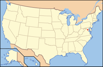
 Cities in the United States.png 1,370 × 854; 64 KB
-
 City park in the afternoon.png 2,054 × 1,156; 4.76 MB
-
 Croquis ville américaine.png 3,010 × 1,944; 549 KB
-
 Dallas and the State Fair of Texas seen from the Top o' Texas Tower.png 5,184 × 3,456; 25.11 MB
-
 Densityhisto.jpg 648 × 382; 29 KB
-
 Downtown Tiffin Ohio 7 23 2022.png 4,032 × 3,024; 10.88 MB
-
 Eick Hochhäuser.tif 3,495 × 2,544; 6.43 MB
-
 Largest cities in the United States by population by decade Visualization.png 1,100 × 700; 106 KB
-
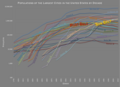 Largest US cities graph.png 1,423 × 1,033; 372 KB
-
 Manitou Avenue - Barker House.JPG 3,122 × 2,228; 2.26 MB
-
 Manitou Avenue - looking east.JPG 2,921 × 2,083; 1.54 MB
-
 Manitou Avenue 12.JPG 2,966 × 2,118; 2.85 MB
-
 Manitou Avenue 2.JPG 3,117 × 2,228; 2.43 MB
-
 Manitou Avenue 3.JPG 2,885 × 2,058; 1.53 MB
-
 Manitou Avenue 8.JPG 3,080 × 2,197; 1.74 MB
-
 Manitou Avenue 9.JPG 3,066 × 2,191; 2.73 MB
-
 Manitou Avenue near Ruxton Avenue intersection.JPG 3,044 × 2,173; 2.15 MB
-
.png/120px-Nicknames_of_American_Cities_(1951).png) Nicknames of American Cities (1951).png 2,000 × 1,541; 1.72 MB
Nicknames of American Cities (1951).png 2,000 × 1,541; 1.72 MB
-
 North Mason St, Bowie Tx - Montague County, TX.jpg 15,000 × 1,800; 15.04 MB
-
.jpg/120px-Panoramas_of_American_Megalopolis_(5388090927).jpg) Panoramas of American Megalopolis (5388090927).jpg 7,525 × 2,499; 2.14 MB
Panoramas of American Megalopolis (5388090927).jpg 7,525 × 2,499; 2.14 MB
-
.jpg/120px-Panoramas_of_American_Megalopolis_(5388118825).jpg) Panoramas of American Megalopolis (5388118825).jpg 7,701 × 2,499; 1.84 MB
Panoramas of American Megalopolis (5388118825).jpg 7,701 × 2,499; 1.84 MB
-
 Row homes, Lower Moyamensing Philadelphia.jpg 3,024 × 4,032; 2.86 MB
-
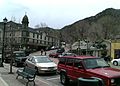
 Ruxton Avenue shops - Manitou.JPG 2,979 × 2,127; 2.23 MB
-
 Springfield skyline.jpg 3,024 × 2,102; 864 KB
-
.jpg/120px-The_Philadelphia_skyline_(cropped).jpg) The Philadelphia skyline (cropped).jpg 2,473 × 1,546; 994 KB
The Philadelphia skyline (cropped).jpg 2,473 × 1,546; 994 KB
-
 The Philadelphia skyline.jpg 2,963 × 3,951; 2.18 MB
-
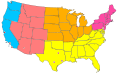 United States Administrative Divisions Cities.svg 959 × 593; 89 KB
-
 United States Administrative Divisions.svg 959 × 593; 120 KB
-
 United States cities over 500,000 population.jpg 779 × 804; 105 KB
-
 Wilson Creek, Washington sign.jpg 1,404 × 1,099; 440 KB
-
 Wylie.png 1,418 × 1,061; 2.73 MB


.png)


.jpg)


.jpg)
.jpg)